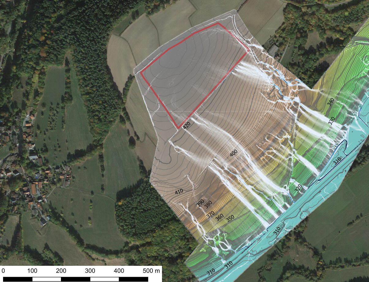
Repeated heavy rainfall in 2017 and 2019 led to mudflows in the municipality of Kauerndorf, which blocked the B289 federal highway. As a preventive measure to prevent further mudflows, our client plans to construct an erosion control structure to reduce the catchment area of future heavy rainfall. We have been commissioned to prognostically examine the effectiveness of the planned structure. For this purpose, runoff models were generated based on the Digital Elevation Model (DEM) with a 1-meter resolution.
Specifically, in the calculation of a runoff model, flowless depressions in the DEM are first eliminated (filled). These are actually traversed and would distort the model without correction (filling). Then, based on the slope, the flow direction of each cell, or each square meter, is determined. This determines into which neighboring cell a water drop in the considered cell would theoretically flow. Based on the flow direction, the runoff for each cell is finally accumulated. Cells with a high runoff accumulation value are areas where surface runoff concentrates.
To assess the effectiveness of the planned erosion control structure, project manager Thomas Struller developed an investigation concept. In the first step, the actual runoff conditions are modeled and validated or calibrated based on field surveys. In the second step, the terrain surface in the model is manipulated to reflect the geometry of the planned structure. The re-modeling of the runoff conditions with the manipulated surface then shows the runoff after the construction of the structure. The effectiveness of the structure can be derived from the difference between the two models.
According to Simon Landgraf, who conducted the modeling and field survey, calibration of the model was not necessary. The initial calculation already depicted runoff lines that exactly matched the reports from residents and the event sketches of the mudflows. This high level of agreement aligns with experiences from other projects, where past flash floods and mudslides could be reconstructed with meter accuracy through runoff modeling, allowing the source or cause of the event to be determined retrospectively.
The second model, which incorporated the erosion control structure, clearly showed that runoff formation in the upper slope can be reduced by the structure. There is hardly any surface runoff in this area, which in turn significantly relieves the erosion channel in the lower slope. Thus, the effectiveness of the erosion control structure could be prognostically tested and demonstrated.